Daasbiyo cave: rock paintings and burial mounds
The Daasbiyo cave lies in the Ali-Sabieh region, in south-east Djibouti, on the territory of a medieval village still inhabited. It is described as the place where the site's first occupants stored their equipment, and as holding rock paintings. The village around it is best known for its funerary mounds, or awellos, and for its role as a trading and religious crossroads between the 10th and 12th centuries.
Where is the Daasbiyo cave?
The Daasbiyo cave lies in the Ali-Sabieh region, in south-east Djibouti, on the territory of the village of the same name. The National Tourism Agency presents it as one of the sites to see when passing through Ali-Sabieh, the “train town”.
Daasbiyo occupies a plain at the foot of the Hadla massif. The village is served by a station of the former Djibouti-Ethiopia line: the railway passes through Daasbiyo before heading west towards the Grand Bara desert. The sector lives from herding and a nascent agriculture.
| Reference | Published data | Source |
|---|---|---|
| Administrative region | Ali-Sabieh | National Tourism Agency; Wikipedia |
| Coordinates of the village | 11.250 N — 42.783 E | Wikipedia |
| Altitude of the village | 581 m | Wikipedia |
| Position | Plain at the foot of the Hadla massif | Wikipedia |
| Distance from Ali-Sabieh | about 15 km north-east | Wikipedia |
| Distance from Djibouti City | about 62 km south-east | Wikipedia |
| Service | Station of the former Djibouti-Ethiopia line | Wikipedia |
| Status of the village | Medieval city still inhabited | La Nation, August 2024 |
Those coordinates are those of the village. No source consulted publishes coordinates specific to the cavity: treat them as an arrival point, not as the entrance to the cave.
What is in the Daasbiyo cave?
It has to be said plainly: what is known about the cave comes down to two sentences, and both deserve to be quoted as they stand rather than embroidered.
The National Tourism Agency writes that the cave served the site’s first occupants to store their equipment: that is the role attributed to it, that of a storage shelter linked to an ancient occupation of the village.
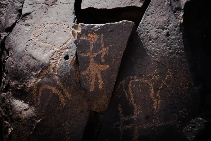
The national press, reporting an official visit in August 2024, mentions the cave’s rock paintings, described as of “ancient times”. That is the only mention of rock art we found.
The published descriptions stop there. Neither the National Tourism Agency nor the national press gives the number of figures, their motifs, their technique or their dating. A visit is therefore prepared without documentary expectation: you will see what a local companion shows you, on a site that is neither equipped nor waymarked.
What do the Daasbiyo tumuli reveal?
It is in fact the funerary context that made Daasbiyo known. The village and its surroundings hold a significant number of tumuli, called locally awellos — aowelo in other transcriptions. The word means in Afar “a heap of stones gathered by the ancestors”.
These monuments are made of black volcanic rocks. Two forms are distinguished:
- flat and circular, with stones set side by side and stelae at the ends, in the plain regions;
- pyramidal, in mountainous areas, where stacking the blocks demands far more material.
The detail that distinguishes them from recent burials is simple: in an ancient tumulus, the whole circle is filled with stones, whereas more recent graves are content to outline it. According to the official source consulted, these complexes go back to about 3000 BCE, more than five millennia ago; construction is said to have obeyed the social status of the deceased, and the sex of the person buried is said to be read from the number of stelae — two for a man, a third at the centre for a woman.
The dating is not a settled consensus: academic work on the aowelos proposes different ranges depending on the author, and the associated material — ceramic sherds, tools, child graves — still feeds the debate about their function, funerary or for observing the territory.
These tumuli appear, with those of the Gobaad basin and the Tadjourah region, on the national tentative list of properties proposed for UNESCO world heritage. They are threatened by looting, and the area’s inhabitants sometimes reuse their blocks to build a shelter or an enclosure: the heritage is alive, fragile, and already reworked.
Why is Daasbiyo a medieval city still inhabited?
Three successive roles explain the importance of the place, and all three are documented.
A trading crossroads. Daasbiyo played an important role in exchanges between the port cities of Zeila and the hinterland. The houses were built of mud and stone, and nomads stopped there for water, on the road to Zeila or Harar. A well, dug in the bed of the wadi crossing the village, supplied the water for those halts.
A religious crossroads. The village was a crossroads between the 10th and 12th centuries. Islam only penetrated the region towards the end of the 13th century, while Zeila was already largely Muslim several centuries earlier. That gap makes Daasbiyo an interesting marker for understanding the spread of the religion along the coast.
A city that survived. This is the most striking point: the national press presents Daasbiyo as one of the country’s medieval cities still alive, whereas its contemporaries are no more than ruins left to archaeologists. The village keeps its station, its century-old well and the remains of a colonial barracks. A camel-back walk leaves there each year towards Ali-Sabieh.
The tumuli, the funerary complexes and the abundance of ceramic sherds on the site attest, according to the National Tourism Agency, to a vanished civilisation. Close by, two Lower Palaeolithic deposits have also been recorded: Armakato, a kilometre and a half north of the village, and the Douré wadi, four kilometres east, where nearly four hundred pieces were collected in 1990.
How do you visit Daasbiyo?
The Dalmar booking catalogue offers no excursion dedicated to Daasbiyo. The visit is therefore arranged from Ali-Sabieh, whose village is about fifteen kilometres away, or fitted into a day devoted to the south of the country.
| Departure point | What it involves |
|---|---|
| Ali-Sabieh | The closest; the natural departure point for the village |
| Djibouti City | About 62 km south-east; the stage is done within the day |
| The railway | The village has a station on the former Djibouti-Ethiopia line |
The region is crossed by car; for sites away from the main roads, access is by track, and local accompaniment is the rule rather than the exception: the tumuli blend into the ground, and no signage is documented. For rail service in the sector, see the page train to Ethiopia.
What should you know before going?
- Do not expect infrastructure. There is no ticket, no published opening hours, no appointed guide documented by the sources consulted.
- Do not touch the paintings, do not wet them and do not rub anything: on that kind of surface, the gesture is enough to erase.
- Collect neither sherds, nor beads, nor bones, nor stones from the tumuli. The country’s awellos are already looted; a stone taken away is a stone lost to research.
- Bring water and sun protection. The region is inland, without shade, and shops are rare around the sites.
- Ask before photographing inhabitants and dwellings: you are not in a deserted site, but in an inhabited village.
- Set off early. Open-air sites are visited in the morning; the afternoon is crushing for much of the year.
Preparing your trip
Daasbiyo combines naturally with the rest of the Ali-Sabieh region: the protected area of Assamo and its Beira antelope, the plain of Grand Bara and its rock engravings, or a stop at Djibouti City before heading down south. On site, allow half a day. Organise your visit before setting off: accommodation is scarce in the region, and the sources consulted document neither ticket, nor opening hours, nor appointed guide on the site.
Frequently asked questions
Where is the Daasbiyo cave?
At Daasbiyo, in the Ali-Sabieh region, south-east Djibouti. The coordinates published for the village are 11.250 north and 42.783 east, at 581 metres of altitude, at the foot of the Hadla massif. The village lies about fifteen kilometres north-east of Ali-Sabieh and about sixty kilometres south-east of Djibouti City. No source consulted publishes coordinates specific to the cavity.
What can you see in the Daasbiyo cave?
Two elements are documented, and nothing more. The National Tourism Agency describes the cave as the place where the site's first occupants kept their equipment. The national press, reporting an official visit in August 2024, mentions its rock paintings. Neither the number of figures, nor their motifs, nor their dating are published by those sources: plan for accompaniment on site.
What is an awello?
An awello, also written aowelo, is a group of basalt blocks forming a circle, which inhabitants call in Afar 'a heap of stones gathered by the ancestors'. They are ancient funerary complexes, made of black volcanic rocks. Two forms exist: flat and circular, with stelae at the ends, in the plains; pyramidal, in mountainous areas. Most lie near Randa, Daasbiyo and in the Gobaad basin.
Is Daasbiyo still inhabited?
Yes, and that is what makes it singular. The national press presents it as one of the country's medieval cities still alive, whereas most of its contemporaries are no more than ruins excavated by archaeologists. The village keeps a station of the former Djibouti-Ethiopia line, a century-old well and the remains of a colonial barracks. A camel-back walk leaves there each year towards Ali-Sabieh.
How do you visit the Daasbiyo cave?
The Dalmar booking catalogue offers no excursion dedicated to Daasbiyo: the visit is arranged from Ali-Sabieh, whose village is about fifteen kilometres away. Plan for a vehicle, local accompaniment and water. Neither the National Tourism Agency nor the national press documents an entrance ticket, opening hours or an appointed guide on the site.
Sources
- Djibouti National Tourism Agency — the da'asbiyo cave
- Djibouti National Tourism Agency — Ali-Sabieh region and the Dhaydhan camp
- La Nation (via Africa-Press) — International Youth Day at Daasbiyo, 13 August 2024
- La Nation (via Africa-Press) — the sites of Djiboutian heritage and the UNESCO tentative list
- Wikipedia — Dasbiyo (village, station, coordinates, history)
- Wikipedia — Aowelo (basalt tumuli of Djibouti)
- World Bank — impact study of the Galafi-Nagad power corridor (awellos, archaeological sites of the Da'Asboyo sector)
Location
Lat. 11.25000Lng. 42.78300
Destinations
Read next
Abourma: the rock engravings of the Makarrassou massif
Ali-Sabieh: the south-east region, sites and camps
Allols depression: salt, hot springs and caravans
Ardoukoba: the most recent volcano in Djibouti
Arta: the cool of the interior and whale sharks
Assamo: the protected area of the beira antelope
Balho: rock art and the northern border post
Bankoualé: the oasis at the foot of the Goda massif